Wayfinding Design
Type: Classroom project
Wayfinding | Signage Design | Environmental Graphics | User Experience | Accessibility
Designing Office Navigation & Signage System for the Bengaluru Water Supply office
A project aimed at creating visual wayfinding aids to simplify navigation, improve information retrieval, and communicate essential information effectively within the Bengaluru Water Supply and Sewerage Board office.
Role: Visual Design, Signage & Collateral Development
Tools used : Illustrator | Photoshop
Duration: 3 weeks(2022)
Wayfinding Design
Type: Classroom project
Wayfinding | Signage Design | Environmental Graphics | User Experience | Accessibility
Designing Office Navigation & Signage System for the Bengaluru Water Supply office
A project aimed at creating visual wayfinding aids to simplify navigation, improve information retrieval, and communicate essential information effectively within the Bengaluru Water Supply and Sewerage Board office.
Role: Visual Design, Signage & Collateral Development
Tools used : Illustrator | Photoshop
Duration: 3 weeks(2022)
Wayfinding Design
Type: Classroom project
Wayfinding | Signage Design | Environmental Graphics | User Experience | Accessibility
Designing Office Navigation & Signage System for the Bengaluru Water Supply office
A project aimed at creating visual wayfinding aids to simplify navigation, improve information retrieval, and communicate essential information effectively within the Bengaluru Water Supply and Sewerage Board office.
Role: Visual Design, Signage & Collateral Development
Tools used : Illustrator | Photoshop
Duration: 3 weeks(2022)


Challenge
The Bengaluru Water Supply and Sewerage Board (BWSSB) is a vital entity responsible for managing water services in Bengaluru, Karnataka. The BWSSB office, located in a bustling residential area, is a hub for water-related services. However, navigating this government office can be daunting, especially for a diverse user base with varying literacy levels.
The challenge was creating visual wayfinding aids to simplify navigation, improve information retrieval, and communicate essential information effectively within the Bengaluru Water Supply and Sewerage Board office.
Challenge
The Bengaluru Water Supply and Sewerage Board (BWSSB) is a vital entity responsible for managing water services in Bengaluru, Karnataka. The BWSSB office, located in a bustling residential area, is a hub for water-related services. However, navigating this government office can be daunting, especially for a diverse user base with varying literacy levels.
The challenge was creating visual wayfinding aids to simplify navigation, improve information retrieval, and communicate essential information effectively within the Bengaluru Water Supply and Sewerage Board office.
Challenge
The Bengaluru Water Supply and Sewerage Board (BWSSB) is a vital entity responsible for managing water services in Bengaluru, Karnataka. The BWSSB office, located in a bustling residential area, is a hub for water-related services. However, navigating this government office can be daunting, especially for a diverse user base with varying literacy levels.
The challenge was creating visual wayfinding aids to simplify navigation, improve information retrieval, and communicate essential information effectively within the Bengaluru Water Supply and Sewerage Board office.
Field Immersion
The first phase of the project entailed visiting the space to identify problems with locating spaces, understanding the background of the space and inquiring with stakeholders to gain insight on their visual perceptions of the space.
Field Immersion
The first phase of the project entailed visiting the space to identify problems with locating spaces, understanding the background of the space and inquiring with stakeholders to gain insight on their visual perceptions of the space.
Field Immersion
The first phase of the project entailed visiting the space to identify problems with locating spaces, understanding the background of the space and inquiring with stakeholders to gain insight on their visual perceptions of the space.
Visuals of the space and Insights from the visits
Visuals of the space and Insights from the visits


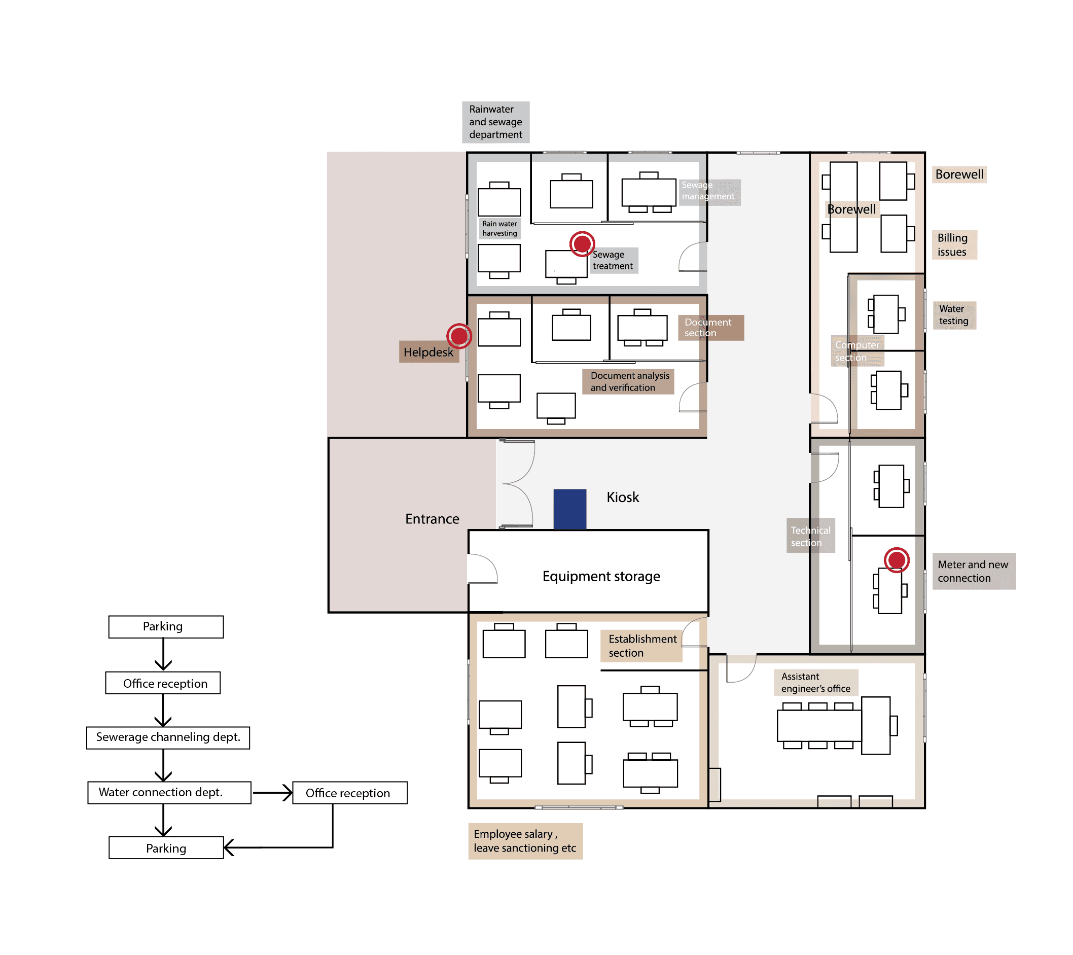
Floor map of the entire office area and the main office building
Floor map of the entire office area and the main office building
Floor map of the entire office area and the main office building


User Research & Insights
Based on conversations with office staff, management, and visitors, key stakeholders, their roles, and the challenges they face navigating the BWSSB office were mapped
Personas were created to represent typical users, from first-time visitors with limited familiarity to frequent visitors, capturing their goals, frustrations, and behaviors
User journey touchpoints were identified across the office experience to highlight critical interactions where visitors require guidance or information
These insights informed the design of wayfinding aids, signage, and visual communication strategies aimed at improving clarity, accessibility, and overall user experience
User Research & Insights
Based on conversations with office staff, management, and visitors, key stakeholders, their roles, and the challenges they face navigating the BWSSB office were mapped
Personas were created to represent typical users, from first-time visitors with limited familiarity to frequent visitors, capturing their goals, frustrations, and behaviors
User journey touchpoints were identified across the office experience to highlight critical interactions where visitors require guidance or information
These insights informed the design of wayfinding aids, signage, and visual communication strategies aimed at improving clarity, accessibility, and overall user experience
User Research & Insights
Based on conversations with office staff, management, and visitors, key stakeholders, their roles, and the challenges they face navigating the BWSSB office were mapped
Personas were created to represent typical users, from first-time visitors with limited familiarity to frequent visitors, capturing their goals, frustrations, and behaviors
User journey touchpoints were identified across the office experience to highlight critical interactions where visitors require guidance or information
These insights informed the design of wayfinding aids, signage, and visual communication strategies aimed at improving clarity, accessibility, and overall user experience
Stakeholder mapping
Stakeholder mapping

Persona mapping
Persona mapping
Persona mapping


User journeys and touchpoints
User journeys and touchpoints
User journeys and touchpoints


Final observations and Insights
Final observations and Insights
Final observations and Insights


Design, Prototyping & Testing
This phase involved exploring and refining visual communication elements for the office.
It included iconography and signage explorations, color and dimension studies, and visibility assessments to ensure clarity and legibility across the space.
Prototypes were tested in context to evaluate effectiveness, and final designs were iterated based on feedback to create a user-friendly wayfinding system.
Design, Prototyping & Testing
This phase involved exploring and refining visual communication elements for the office.
It included iconography and signage explorations, color and dimension studies, and visibility assessments to ensure clarity and legibility across the space.
Prototypes were tested in context to evaluate effectiveness, and final designs were iterated based on feedback to create a user-friendly wayfinding system.
Design, Prototyping & Testing
This phase involved exploring and refining visual communication elements for the office.
It included iconography and signage explorations, color and dimension studies, and visibility assessments to ensure clarity and legibility across the space.
Prototypes were tested in context to evaluate effectiveness, and final designs were iterated based on feedback to create a user-friendly wayfinding system.
Finalised signs and Information displays
Finalised signs and Information displays
Finalised signs and information displays


Prototype Evaluation: Assessing Dimensions and Visibility, Followed by Inferences
Prototype Evaluation: Assessing Dimensions and Visibility, Followed by Inferences


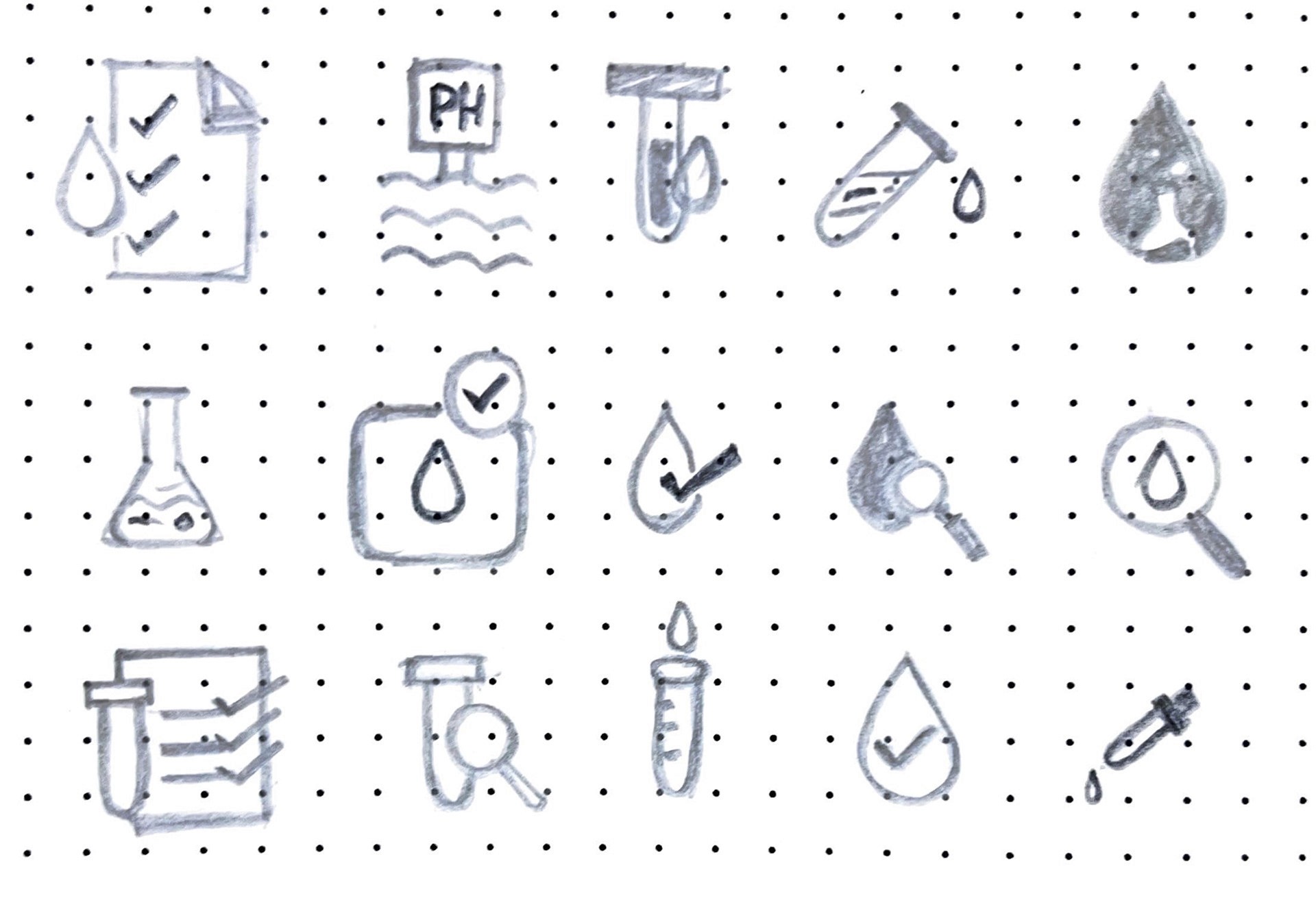
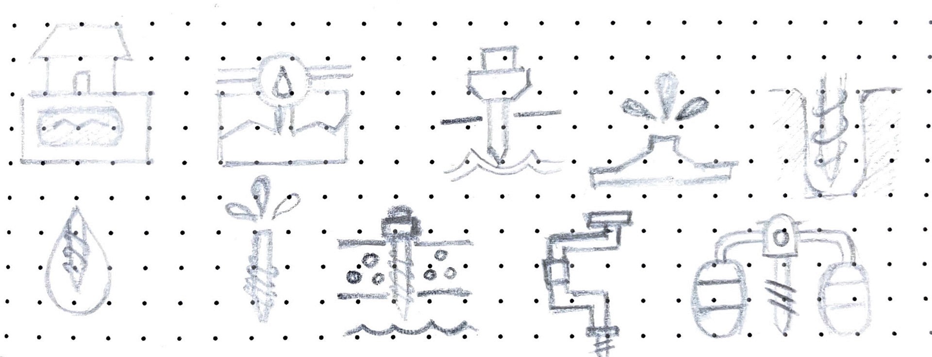
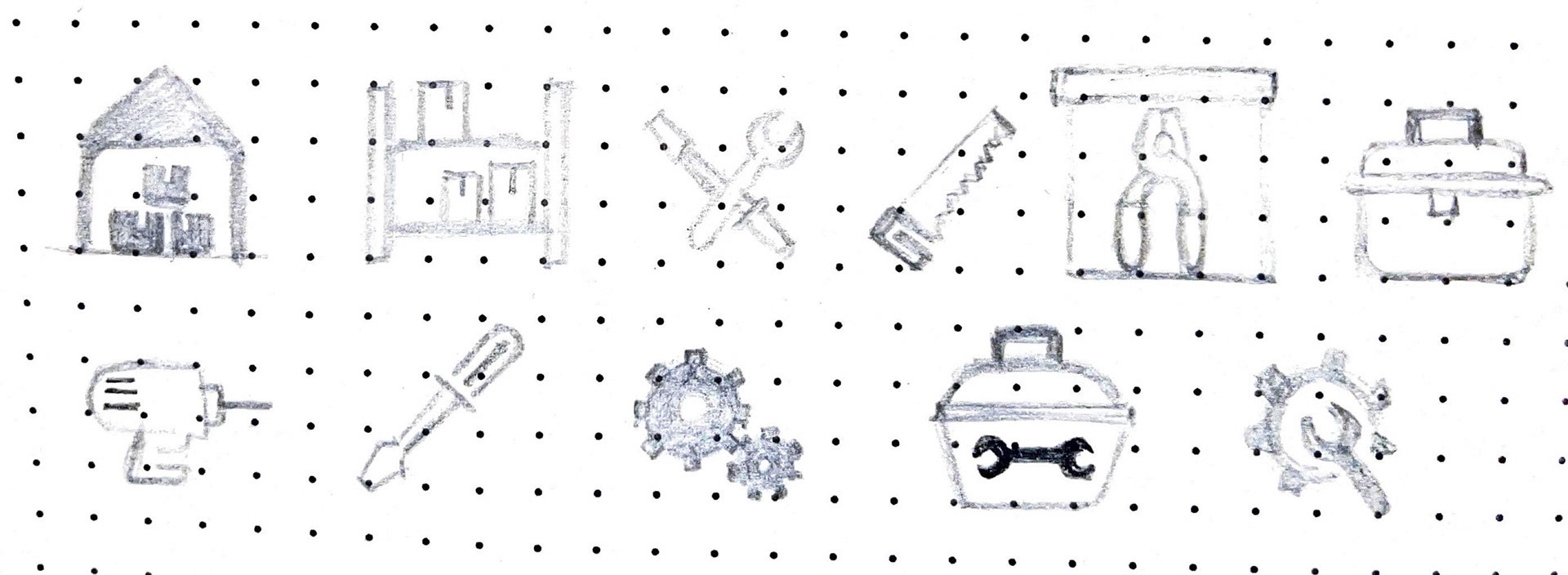
Initial explorations Some rough explorations for the visual representation for all the signs (from left to right ) Parking , Sewage , Kiosk, Meter Reading , Rain water harvesting , Borewell ,Water testing , Equipment storage
Initial explorations Some rough explorations for the visual representation for all the signs (from left to right ) Parking , Sewage , Kiosk, Meter Reading , Rain water harvesting , Borewell ,Water testing , Equipment storage






Former digitalised colour explorations
Former digitalised colour explorations


Conclusion & Key Takeaways
This project served as an explorative exercise in understanding and designing for real-world environments.
By interacting with stakeholders and observing the space firsthand, valuable insights were gained into how users perceive and navigate visual information.
The exercise highlighted the importance of clarity, legibility, and contextual relevance in wayfinding design. It also provided practical experience in stakeholder engagement, user testing, and iterative refinement, emphasizing the nuanced considerations required to create effective visual communication systems.
Conclusion & Key Takeaways
This project served as an explorative exercise in understanding and designing for real-world environments.
By interacting with stakeholders and observing the space firsthand, valuable insights were gained into how users perceive and navigate visual information.
The exercise highlighted the importance of clarity, legibility, and contextual relevance in wayfinding design. It also provided practical experience in stakeholder engagement, user testing, and iterative refinement, emphasizing the nuanced considerations required to create effective visual communication systems.
Conclusion & Key Takeaways
This project served as an explorative exercise in understanding and designing for real-world environments.
By interacting with stakeholders and observing the space firsthand, valuable insights were gained into how users perceive and navigate visual information.
The exercise highlighted the importance of clarity, legibility, and contextual relevance in wayfinding design. It also provided practical experience in stakeholder engagement, user testing, and iterative refinement, emphasizing the nuanced considerations required to create effective visual communication systems.
Not everything here's polished yet, but the heart of it is here :)
Thanks for visiting!
Not everything here's polished yet, but the heart of it is here :)
Thanks for visiting!
Not everything here's polished yet, but the heart of it is here :)
Thanks for visiting!